


La Sal Mountain Range as seen from Arches N.P.
I have always been fond of the La Sal Mountain range. They provided a nice backdrop to many of my photos taken on visits to the Moab and Lake Powell area. It never occurred to me to climb them though… until I ‘met’ Mike/KØYO.
Mike commented on my trip report to Mount Werner, an area that he is very familiar with. We started to exchange e-mails about SOTA and summits in Utah where he now lives, and soon started to make plans for activating some of the summits in the La Sal Range for the upcoming season.

La Sals as seen from Delicate Arch
The La Sals can carry snow until August which can make an ascent of the rather steep slopes hard if not impossible. Luckily for us, it had been a very dry winter in Utah and most of the snow was already gone. With the weather forecast in our favor, we set a date and within 5 days I was on my ~550 mi (ca. 900 km) journey to Utah.
The mountain range contains of two clusters of peaks and rises high over the surrounding Colorado Plateau. It has several major peaks and six of them are currently SOTA peaks:
- Mount Peale – W7/SU-062 – 12,721 feet (3877 m)
- Mount Mellenthin – W7/SU-001 – 12,645 feet (3854 m)
- Mount Tukuhnikivatz – W7/SU-002 – 12,482 feet (3805 m)
- Mount Waas – W7/SU-003 – 12,331 feet (3758 m)
- Manns Peak – W7/SU-004 – 12,272 feet (3741 m)
- Mount Tomasaki – W7/SU-005 – 12,239 feet (3730 m)
During the preparation we debated for a while where to set-up our base-camp to make the activations as efficient as possible. We went back and forth but finally settled on the Geyser Pass area because both clusters can be easily reached by foot from the pass. Since Mike was leaving earlier than me… that’s where we planned on meeting.

Along the Colorado River – Scenic Byway to Moab
I left my QTH early in the morning on May 29th , hoping to arrive around 5PM at our base-camp. Traffic was light on I25 as well as I70 and I made good time with just one pit stop to re-fuel the car and to get some caffeine in my system. I took the scenic byway to Moab along the Colorado river. Route 128 has always been a favorite of mine. From Moab it is another hour to get to Geyser Pass, mostly over dirt-roads. I was pleasantly surprised about the good condition of the dirt road in the Manti La Sal National Forest. Besides all the fallen trees along and over the road, my old Subaru Outback had no issues until Geyser Pass… then the ‘road’ condition changed and I was moving at a snails pace to navigate the holes and uneven track towards the base-camp. I received a phone call from Mike just a few hundred yards before reaching the pass. He was investigating possible routes to Mt. Mellenthin when he picked-up a cell signal. He gave me the crucial details on where to find his camp. Perfect timing – just 15 minutes later I discovered his truck in the trees, just

La Sals – I found Mike’s camp
below Mount Tomasaki. The final approach was tough for the old Outback but with spinning wheels I (barely) made it up the steep, dusty and bumpy ‘road’ to the camp.
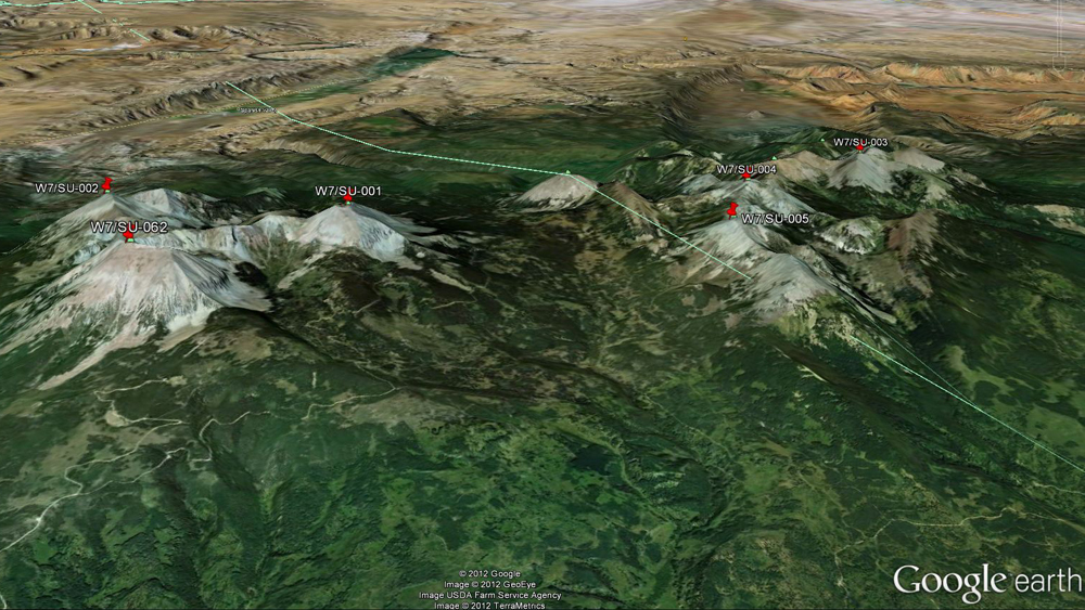
La Sal Mountain Range: SOTA summits (click picture to enlarge)
Mike was still out exploring and since I had been sitting in the car for almost nine hours, I needed some exercise. I took my HT and hiked up towards Burros Pass to explore the ascent to Mount Manns and Mount Tomasaki. I continued uphills, making good progress towards Mt. Manns when Mike called me on 146.52 – he was back at the camp. I turned around and 45 minutes later, we finally met in person.
After dinner we discussed out plans for the coming day and turned to the sleeping bags early…
Video Impressions:
If you have not yet seen the trailer… here it is:
httpvh://www.youtube.com/watch?v=mlmn-0oBoVc
or move on to Part 2 of the trip. If you would like to leave questions or comments, please do so through Youtube.
![]() !! WARNING !! There are old mountaineers, and
bold mountaineers... there are no old-bold mountaineers.
Hiking and mountain climbing are potentially hazardous activities particularly in Colorado with its extreme elevations. I am not accepting responsibility for any death or injury resulting from activations based on my trip reports. Proper training, experience, and personal capability assessment is required - enjoy!
!! WARNING !! There are old mountaineers, and
bold mountaineers... there are no old-bold mountaineers.
Hiking and mountain climbing are potentially hazardous activities particularly in Colorado with its extreme elevations. I am not accepting responsibility for any death or injury resulting from activations based on my trip reports. Proper training, experience, and personal capability assessment is required - enjoy!