


W7U/GR-044
5580
1701 m / 5580 ft
Dec 03, 2015
By KX0R
Summit 5580 is an interesting, challenging summit. It’s probably the easiest SOTA “peak” in Arches National Park, north of Moab, Utah.
• High desert activation
• Most of the hike is on a marked trail
• Parts of the route are along the tops of high rock fins
• Incredible scenery
• Peak is near the famous Double-O Arch
• Activation zone is accessible by hiking and easy scrambling
• Actual summit is a technical climb
• ~ 5.0 miles round trip
• ~ 400 vertical feet of gain to the activation zone
• Hike and activation take about 5 hours
• SOTA “Classic”!
-
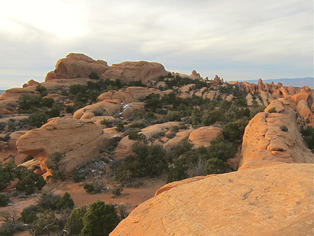
- 5580 Summit View
I relied on the directions posted by K7ODX on the SOTA summit page, and they’re helpful and accurate. Fortunately I had been out to Double O Arch a couple of times previously, so I was familiar with the interesting hike on the “primitive trail”.
The route to 5580 begins at the popular Devils Garden Trailhead. The scenic trail is easy for the first mile to Landscape Arch; then the route becomes more challenging, as it climbs up and travels along “fins” of firm red sandstone. Cairns and a few signs mark the way. There’s some exposure to heights, but the danger is minimal if the sandstone is dry.
-
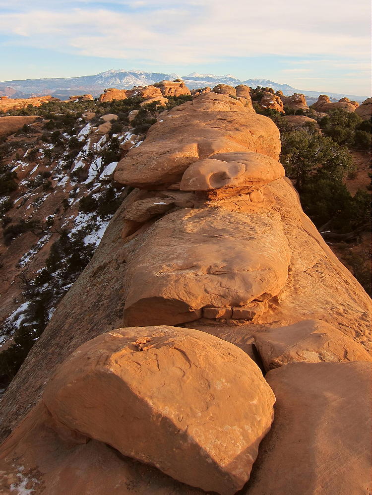
- 5580 Primitive Trail along Fin
If there’s snow or ice on the rocks, leave this trip for another day! I was able to complete the route on Dec 3, 2015, and there was about an inch of snow in the shade; fortunately almost no snow remained on the exposed rock of the trail.
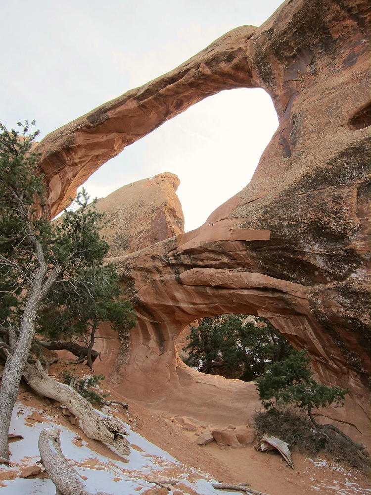
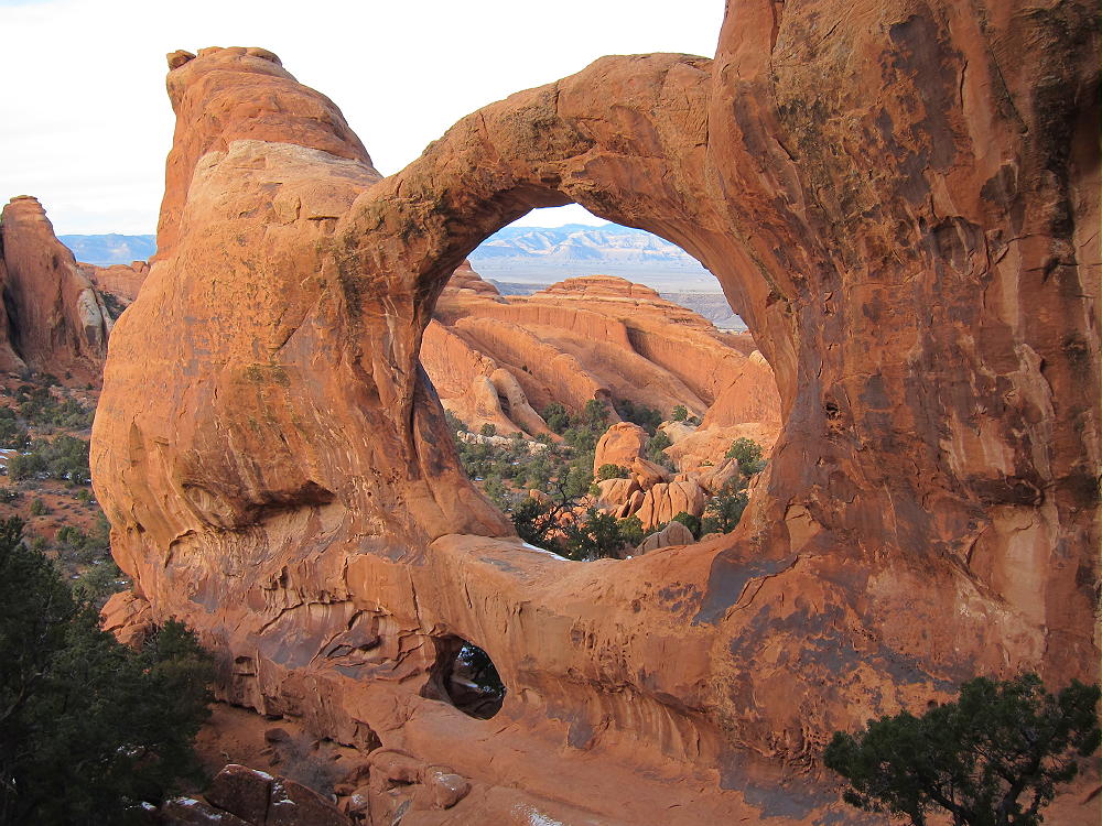
Just beyond 2 miles from the trailhead, the trail descends along a very long fin and drops around a corner to Double O Arch. This is a good place to take some photos and enjoy the magnificent twin arches.
-
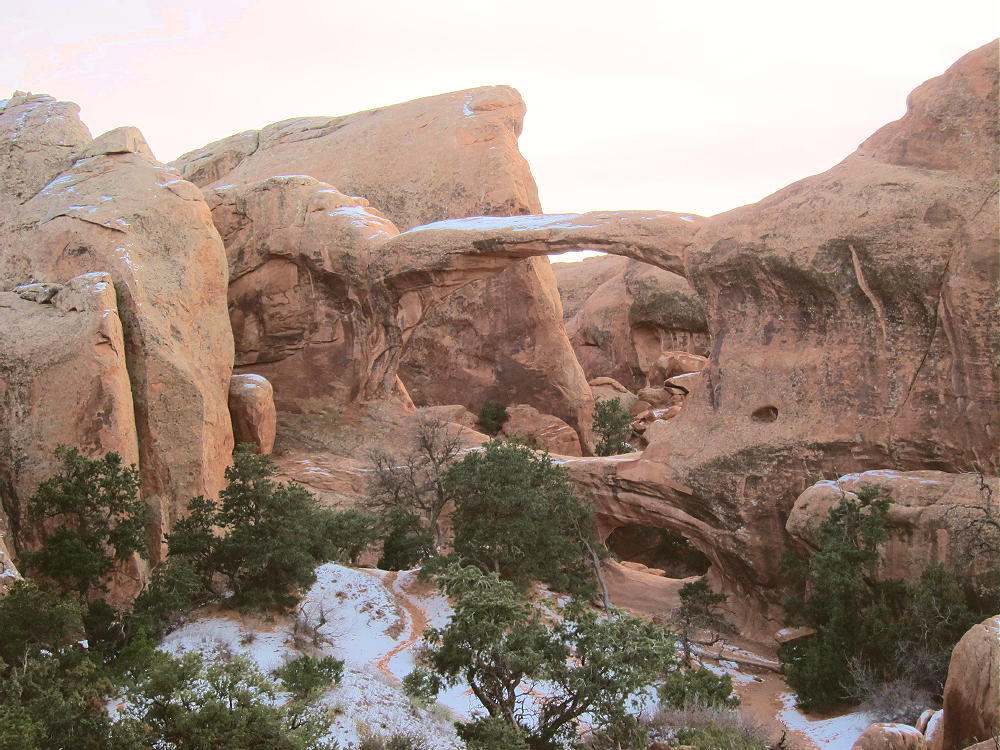
- 5580 Summit behind Double O Arch
It’s possible to climb through the smaller lower arch, but I decided to go around the long way to the north. Follow the marked trail to the Dark Angel for a short distance around the rock fin containing Double O Arch, and then head southeast up an obvious path to the west side of the arch. If the rock’s dry, it’s possible to climb up on the slick-rock and ascend up the draw south of the arch.
Peak 5580 is at the top of the large fin south of Double O Arch, but the summit isn’t visible from near the arch. W7ODX suggests studying the satellite image of the area near Double O Arch prior to going in there, and he’s right. You can’t activate this summit unless you know where you’re supposed to be! 5580 is not climbable by ordinary people, but it’s practical to reach the Activation Zone. Your goal is to climb up to the sandy high point between the Double O Arch fin and the 5580 fin. If you set up on the top of the sand pile up there, right below the 5580 fin, you’ll be within the Activation Zone. My GPS measurements, when compared to topographic map elevations, confirm that the spots W7ODX and I have used are in the Activation Zone. His coordinates are within GPS accuracy of mine:
W7ODX:
N38 47.912’
W109 37.235’
KX0R:
N38 47.907’
W109 37.232’
We arrived at these points independently. Although I used W7ODX’s excellent route description, I recorded my waypoint where I set up my gear. I didn’t go to his coordinates with a recorded waypoint on my GPS, etc.
-
- 5580 Activation Site & Antenna
There’s room to suspend a wire from the operating position, across the open space, to a tree on the other side. Small trees on top of the dune could be used to support a wire, but a pole is better. I used a 20-foot Black Widow pole on top of the dune, and the northeast end of my 52-foot wire was slightly lower. Initially I was pessimistic about the compromised location down between the large sandstone fins. While there are better spots to set up and string an antenna up there, either they’re inaccessible, or they’re likely not within the activation zone.
My doubts disappeared as soon as I got on the air. There was normal band noise as I tuned up on 40M. I made three contacts on 40M CW immediately, followed by a long run on 20M CW, with 26 contacts and reasonable signal reports. Then I went to 30M CW and made 5 more contacts. There really was very little reduction in performance compared to a summit-top setup. It was a long one-hour session sitting in the deep blue winter shade, late in the afternoon, surrounded by snow, with my CW fingers near freezing! The thermometer read 30F at 2200Z, and I had to use gloves and a cloth around the Palm paddles for most of the activation. Of course it was fun!
-
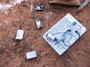
- 5580 Activation Gear
-
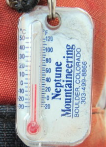
- 5580 Activation Temperature
Activating 5580 on a good day should be a spectacular and rewarding experience. The hike is more than scenic – it’s awesome to walk along the tops of the giant Entrada sandstone fins, with incredible views of the red-rock all around, and the snow-covered La Sal Mountains in the east. There are side trips to several large arches, and nothing up there is less than incredible!
-
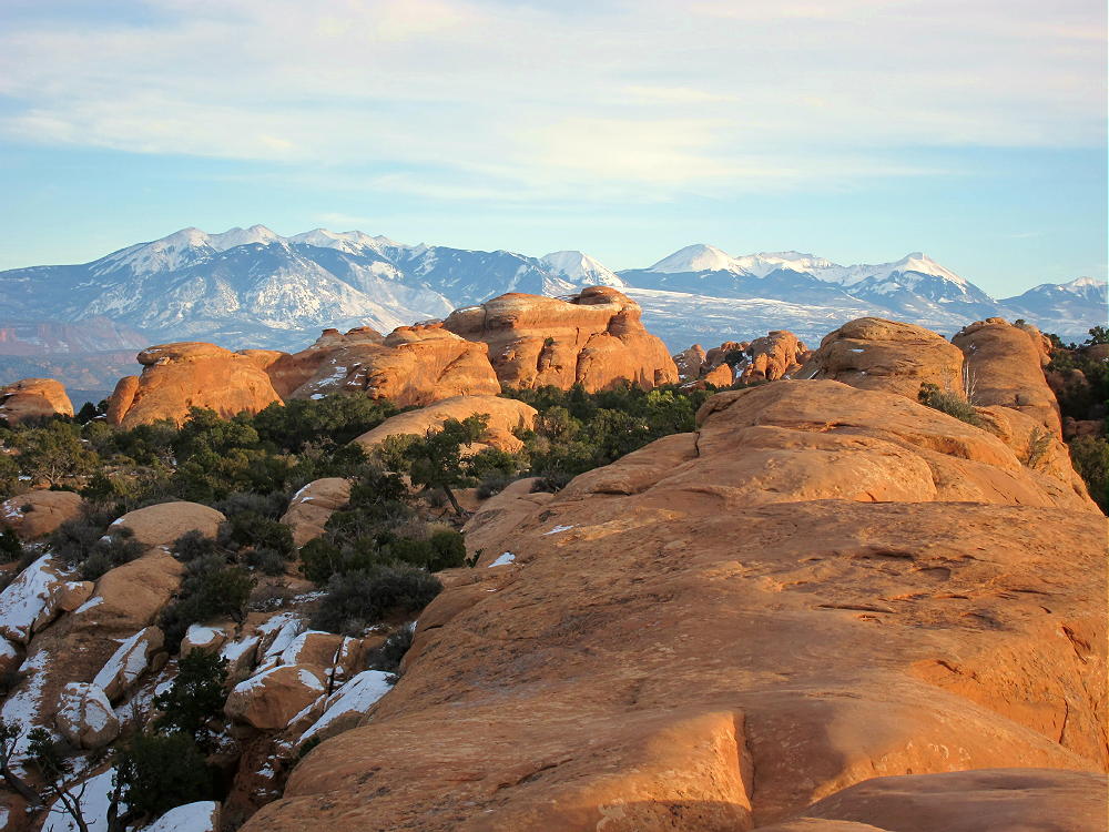
- 5580 Route with La Sal Mountains
There are a few possible problems with this expedition:
1. The Devils Garden area is so popular that it can fill up during busy times.
2. The hike’s dangerous or impossible if the rock’s snowy or icy
3. Summer conditions during mid-day can be so hot that it’s unpleasant or unsafe – take plenty of water.
4. If you stay out there too late, it might be difficult to find the way back via the “primitive trail” in the dark.
5. There’s no VHF/UHF coverage from the activation spot between the fins. Unless you can climb much higher, there are no good options, except for HF.
If you plan to activate 5580, arrange your trip to avoid these problems. You’ll be rewarded by an exciting, fun hike through incredible rock formations. The SOTA activation will be a nice rest-stop in a unique destination. Except for cold fingers during my activation, my trip on December 3 was wonderful!
5580 is a SOTA Classic!
• Fun, spectacular hike
• Incredible scenery
• Challenging three-dimensional route
• Numerous famous arches nearby
• Low-noise HF site
• Unique location in world-class National Park
If you have time, consider continuing out along the marked trail to the Dark Angel. This well-named spire is visible for miles, and it’s larger than you think!
73
George
KX0R
-
- 5580 Summit behind Double O Arch 2
-
- 5580 Double O Arch
![]() !! WARNING !! There are old mountaineers, and
bold mountaineers... there are no old-bold mountaineers.
Hiking and mountain climbing are potentially hazardous activities particularly in Colorado with its extreme elevations. I am not accepting responsibility for any death or injury resulting from activations based on my trip reports. Proper training, experience, and personal capability assessment is required - enjoy!
!! WARNING !! There are old mountaineers, and
bold mountaineers... there are no old-bold mountaineers.
Hiking and mountain climbing are potentially hazardous activities particularly in Colorado with its extreme elevations. I am not accepting responsibility for any death or injury resulting from activations based on my trip reports. Proper training, experience, and personal capability assessment is required - enjoy!